Real Estate
Real Estate: Land and rights therein and whatever is attached to it, by nature or man.
Tasmanian Surveying Consultants
Make direct contact with the principal:
0419 353 414 or Elliott 0428 224 353
info@cromersurveyors.com.au
Real EstateReal Estate: Land and rights therein and whatever is attached to it, by nature or man. |
Real Property Act |
RecisionRecision: A procedure by which the parties to a contract mutually agree to release each other. A contract may also be rescinded by the action of one party against another who fails to meet one more conditions of the agreement. For example, a purchaser fails to effect settlement of a purchase by the due date of contract. Generally, a recision of this type is obtained by Court Order. |
Recorder of TitlesRecorder of Titles: means the principal officer (of the Lands Titles Office or LTO) appointed by the government to administer the register of land titles in the state. His office is the home of the List.
|
Remark or Repeg Surveysglossary image: 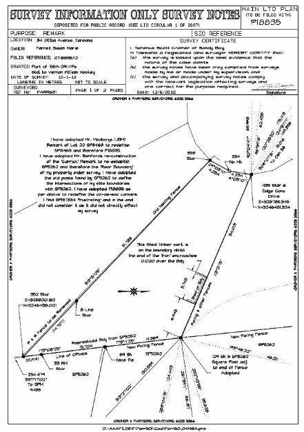 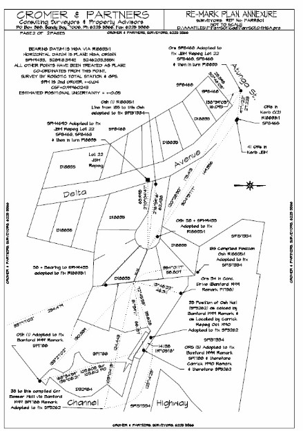 Remark or Repeg Surveys: The surveyor is responsible by State Legislation to ensure the integrity of the State Cadastre. He\she has delegated authority to undertake boundary definition within the State to a specified standard. The survey must be undertaken in accordance with accepted Survey Methodology and results in a Plan being produced. If instructing firstly have a look at those links relating to Survey Fees, Terms of Contract and Survey Methodology. Sometimes, within the course of a field survey, it becomes apparent to the surveyor that there is a problem or a particular aspect of his\her survey that requires further investigation and clarification. This may only be apparent once the surveyor enters the field to undertake his\her survey. Consequently, in some cases, estimates are exceeded in the course of the surveyor carrying out his\her resposibilities as described in the relevant Acts. We will always attempt to contact the client from the field to explain this situation if it arises and the reason for the increase in estimated fees. In some cases such increases can be quite onerous. Matters that effect the Boundary Redefinition process are (but not restricted to): 1. The age and proximity of the most recent adjoining surveys and the survey marks that may or may not still exist. The older the most recent survey, the less likelihood that survey marks from that survey still exist. Unfortunately, the existence of such marks cannot be confirmed until the survey is under way. In many cases there are NO marks left in the vicinity. This then requires the surveyor to survey to out lying corners to either find additional old marks OR to utilise other further afield evidence to satisfy himself the land that his client is entitled to. 2. The slope of the land. 3. The extent and thickness of the vegetation. Note that surveys by GPS require reasonably clear access to the sky. 4. The proximity or otherwise of Map Grid of Australia (MGA) survey control marks. (we are now required by law to connect to such MGA control). These are red coloured ‘brass plaques’ placed at random throughout the state. 5. All surveys that involve the placement of survey marks MUST be registered at the Lands Titles Office by means of the preparation of a Plan and lodging of same. 6. See notes below concerning Boundary Redefinition for reasons why estimates are sometimes exceeded & Survey Methodology for an explanation of why we do what we do! Survey Methodology: Historically, surveyors entered the field with pack horses, a cook, camp equipment, someone to look after the horses, 5 chainmen, some axemen and most likely a survey assistant or two. Field work represented 95% of the time involved and therefore the equivalent percentage in the final fee. We have been gradually working towards a situation where now with such ‘tools’ as GPS (note not always the total solution) we spend 50% of the time in the field and the remainder in front of the computer. Boundary Surveys & solutions by GPS require very good preparation and uploading of resultant data to the GPS Data Recorder. GPS is simply another, quicker way of measuring. It does not supply a magical solution to boundary issues but allows the surveyor to more quickly seek solutions in the field, if he\she is well prepared. His\her expertise is still required to form an opinion of the boundary entitlements in accordance with accepted practice (best available evidence). Some regulations that come into play when boundaries are under survey are: (A) The surveyor must form an opinion of the location of the end of a boundary line if attempting to place a mark along the boundary line (ie a line peg). (B) The surveyor must connect into to adjoining boundaries by their surveys or the best available evidence to ensure that adjoining properties maintain their entitlements. (C) Best available evidence may mean, due to lack of information or evidence, that the surveyor must measure further afield to come to a ‘best’ opinion. Note that ‘further afield’ can mean either further ‘away’ in distance or further back in time and age of surveys to come to a considered opinion. (D) Measurements are not necessarily what boundary definitions are about. A quote from A G Foxhall’s Handbook for Practising Land and Engineering Surveyors: “In the absence of evidence to the contrary the following is the order in which different methods of definition should be adopted, subject to abnormal conditions: (1) Natural features, such as rivers, cliffs etc. (2) Original marking of grant boundaries, road surveys, alignment or resumption surveys. (3) Monuments and abutments. (4) Original marking of private surveys. (5) Occupations. (6) (Lastly, and least satisfactory and only to be adopted when the previous methods do not apply) measurement. This order is not arbitrary,……” Measurement is a ‘tool’ used by the surveyor to assist in forming his\her opinion of a boundary. Once he\she has formed an opinion the surveyor then must mark and reference his\her survey and provide appropriate measurements on a plan lodged with the Recorder of Titles. The need to undertake new survey measurements to a certain accuracy (as set down by legislation) and prepare a plan is to ensure that in future, the then surveyor can rely on those measurements and plan to assist in redefining the relevant boundaries. Please Contact us if you have any queries in relation to this matter HOW WE ASSIST: If you are going to fence your property or build close to a boundary then you need to know where your boundaries are. Our advice could save you money, particularly if a full boundary re-mark survey is not really necessary for your project. Contact us for advice in relation to these matters. |
Required for Wideningglossary image:  Required for Widening: means that an obligation runs with that land to dedicate it as a highway when requested to do so by the highway authority. The authority must tender an amount in compensation which would normally be determined as at the date the widening line was originally set out on the sealed plan. See the dotted line running through lot 2 on the plan adjoining. NOT to be confused with the word "ROAD" on a Sealed Plan, which has a precise legal meaning and dedicates the land NOW as Public Road. SIMPLY In the course of obtaining a permit from a local authority to subdivide a parcel, some portion of the land may be required in the future for road widening purposes. This land can be taken at the time of subdivision and is shown as 'Road Widening' on the survey plan, or can be taken at a later date and is shown as 'Required for Road Widening' |
RequisitionRequisition: in respect to Land Titles Office documentation means a written notice from the Recorder of Titles requiring additional, amended or other specified information prior to a dealing under examination being registered or otherwise dealt with. Requisitions with respect to a Sales and Purchase Agreement (Contract): allows for the buyer's solicitors to examine the property title. If there is a problem with the title, or if a local authority requires works to be carried out, the buyer may ask (requisition) that the vendor fix these problems or they may have cause to cancel the contract. It also commonly refers to the questions one solicitor may ask of another in relation to his or clients ' title. SIMPLY: May also be a request for additional information or fees from the ‘Recorder of Titles’. Occurs when a dealing such as a subdivision lacks complete data to enable final issue of new titles; served on the surveyor or solicitor or associated professions. HOW WE ASSIST: Surveyors and Solicitors are ‘at pains’ to avoid requisitions. We can assist by determining the nature of the ‘holdup’, the requisition, and ensuring a prompt response |
ReserveReserve: means land dedicated on a Sealed Plan in the name of the Crown for reserve purposes (sometimes specified by suffix to the term). See Reserved Road. Note quite often similar to Public Open Space, which is or should be in the name of the Council, whereas Reserves are in the name of the Crown. See also Crown Reservation, which is land Reserved out of a grant for reservation purposes (as compared to being dedicated by a Sealed Plan). |
Reserve PriceReserve Price: The reserve price is the minimum price (kept between the seller and the auctioneer) the seller will accept for their property at an auction. Buyers must bid to it or they above to purchase. |
Reserved Roadglossary image: 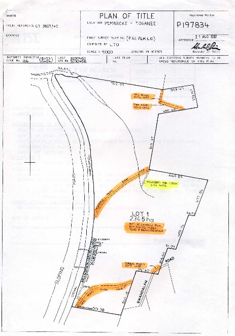 Reserved Road: is a strip of land reserved in a Grant of Crown Land to be used as access through it to adjoining land. It is not a Public Road unless and until it has been proclaimed as such nor is it under the control of the local Council. With reference to the attached plan it should be noted that whilst the Reserved Road passes through this title, it is not Part of the title; it is EXCEPTED OUT as can be seen by the words underneath the 'Area' shown on the plan; it is "Not Included" |
RFI Request for Further InformationRFI Request for Further Information: Councils have 42 days to assess a Development Application. If they or their advisory bodies such as TasWater form the opinion that the application needs further supporting Reports or advice they have the right to forward a Request for Further Information (RFI) to the applicant. The 'clock' stops whilst this request is made and satisfied. We usually advise clients that: "We advise that even though the proposal complies with Council’s planning for the area, approval is not automatic. Recent experience would indicate that Council’s might also need to be determining the effect on the amenity of the area of the development. Such matters as overshadowing, useability of private open space, solar access, driveway location, vehicle movements and height and scale of the potential development may need to be considered. (Council could also ask for details of the extent and type of vegetation on proposed lots, details and a report on the landscape and scenic issues of the site, details of waterways on and within the immediate area, including water holes and dams, details of contours on the entire site, a longitudinal section and cross sections of any proposed road, compliance with fire requirements, method of creek or river crossings and the like). Having regards to these matters, we advise that we may receive a request from Council to provide additional information relating. We feel now that it is more cost effective to lodge the application without providing such additional information and await feedback from Council. For example, a recent request from a local Council sought advice on the following matters:
· Land capability (agricultural potential);
· Bushfire hazard assessment;
· Biodiversity assessment;
· Visual impact assessment;
· On-site waste disposal;
· Access;
· Impacts on adjoining Creeks and other waterways. Whilst we are not experts in the above fields, we advise that reports attending to the above matters or similar are not cheap, hence our reluctance to provide with a preference to wait to see what Council's issues are and respond to their queries." In a residential area good example of such an RFI is TasWater's requirement that an Engineering Report is prepared reflecting the current and proposed servicing of a Residential Subdivision. If such a report is not prepared at the time of lodging TasWater will issue an RFI.
|
Right of Carriagewayglossary image:  Right of Carriageway: means a right for a person authorised to do so to drive a vehicle over specified parts of another persons land at any time. Also referred to as a Right of Way. See the dotted line running through Lot 15 on the adjoining plan. Any land which is shown on a sealed plan as a road, street, alley, lane, court, terrace, footpath or other kind of way is taken to be dedicated to, and accepted by, the public unless called “private” on the plan (section 95(1) LGBMP Act 1993) “private” in relation to a way, means not subject to use by the public as of right (section 3 LGBMP Act 1993) Any "Right" is an Easement. See Easement, Transfer of for how easements and therefore Rights are created. A right of carriageway is a positive easement benefitting a dominant tenement and burdening a servient tenement.
Maintenance of a Right of Carriageway: The nature of easements are complex and are generally governed by the courts using both common law and case law precedents. Depending how an easement is created, it is normal practice for the dominant tenement to maintain the easement site - as part of the bundle of rights granted - which are said to run with the land. Generally speaking, there is no obligation on a servient tenement to maintain a right of way in use by others. But
Seek legal advice! SIMPLY: This means that you cannot restrict the right of someone to pass over that portion of a title that is defined as 'Right of Carriageway, nor can you build a structure over such area. HOW WE ASSIST : We can determine the location of such a Right of Carriageway on the ground and on plan to allow the design and construction of structures that do not intrude on this right. |
Right of DrainageRight of Drainage: means the right for a person authorised to do so to construct, maintain and repair sewers and drains over specified parts of another persons land for the removal of stormwater and other surplus water, but without doing unnecessary damage to the other persons land Any "Right" is an Easement. See Easement, Transfer of for how easements and therefore Rights are created. SIMPLY: The right of someone else to drain through your land, to lay and maintain pipes. You cannot usually build over such rights of drainage as you must maintain their right to lay and maintain. Not all pipes (eg Council sewers)need to have a drainage right. HOW WE ASSIST We can determine the location of such a right on the ground and on plan to ensure this right is not intruded upon. |
Right of Footwayglossary image:  Right of Footway: means a right for a person authorised to do so to walk or bicycle over specified parts of another persons land at any time. Not to be confused with the 'Notation' on a Sealed Plan "FOOTWAY" (see lot 17 on the adjoining plan) which actually dedicates the land for the Public Use (even though the title may still be in the original subdividors name). A Right of Footway authorises a specific person or persons (by naming their title as benefiting) to use portion of another title for footway purposes, NOT the general public. Any land which is shown on a sealed plan as a road, street, alley, lane, court, terrace, footpath or other kind of way is taken to be dedicated to, and accepted by, the public unless called “private” on the plan (section 95(1) LGBMP Act 1993) “private” in relation to a way, means not subject to use by the public as of right (section 3 LGBMP Act 1993) Any "Right" is an Easement. See Easement, Transfer of for how easements and therefore Rights are created. SIMPLY: HOW WE ASSIST : We can determine the location of such a footway on the ground and on plan to allow the design and construction of structures that do not intrude on this right. |
Right of Light and AirRight of Light and Air: means the right for a person to ensure that they preserve the provision of light and air by prohibiting building or block out within a specified area on adjoining land. Any "Right" is an Easement. See Easement, Transfer of for how easements and therefore Rights are created. SIMPLY: means the right for a person who has a window or building on or near a boundary to enjoy the continuing transmission of light and air without being built out or blocked out by an adjoining neighbour. HOW WE ASSIST : We can determine the location and extent of an existing light and air easement, or we can measure up and set out a new light and air site for easement registration purposes. |
Right of Wayglossary image:  IN GENERAL: IF YOU HAVE A RIGHT OF WAY RUNNING THROUGH YOUR LAND THAT IS TO THE BENIFIT OF ANOTHER LAND OWNER YOU MUST NOT DO ANYTHING THAT IMPEDES THE USE OF THAT RIGHT OF WAY BY THE OTHER LAND OWNER. THIS MEANS YOU CANNOT PARK, RESTRICT, GATE OR STOP THE OTHER OWNER USING THE STRIP OF LAND TO PASS AND REPASS. Gates in a Rural Area would appear reasonable if keys are made available
Right of Way: means a right for a person authorised to do so to drive a vehicle over specified parts of another persons land at any time. See the dotted line running through Lot 15 on the adjoining plan. Any land which is shown on a sealed plan as a road, street, alley, lane, court, terrace, footpath or other kind of way is taken to be dedicated to, and accepted by, the public unless called “private” on the plan (section 95(1) LGBMP Act 1993) “private” in relation to a way, means not subject to use by the public as of right (section 3 LGBMP Act 1993) Any "Right" is an Easement. See Easement, Transfer of for how easements and therefore Rights are created.
Maintenance of a Right of Carriageway: The nature of easements are complex and are generally governed by the courts using both common law and case law precedents. Depending how an easement is created, it is normal practice for the dominant tenement to maintain the easement site - as part of the bundle of rights granted - which are said to run with the land. Generally speaking, there is no obligation on a servient tenement to maintain a right of way in use by others. But
Seek legal advice! SIMPLY: HOW WE ASSIST : We can determine the location of such a Right of Way on the ground and on plan to allow the design and construction of structures that do not intrude on this right. |
Right of Way, Maintenance ofMaintenance of a Right of Carriageway: The nature of easements are complex and are generally governed by the courts using both common law and case law precedents. Depending how an easement is created, it is normal practice for the dominant tenement to maintain the easement site - as part of the bundle of rights granted - which are said to run with the land. Generally speaking, there is no obligation on a servient tenement to maintain a right of way in use by others. But Seek legal advice! |
River (creek or stream) bankRiver (creek or stream) bank: in relation to a boundary means the elevations of land that contain the average flow of water within a defined channel disregarding extraordinary flows of either flood or drought. SIMPLY: A river that may be described as the boundary of a title defines that boundary by it's average flow of water within a defined channel; it means that if the river is in flood the boundary does not move with the flood water. HOW WE ASSIST: The interpretation of boundaries is an opinion that the Authorised Surveyor forms using the best available evidence that the nature of the case allows. River boundaries are rarely debateable in terms of their location; the final boundary will be as determined by the best available evidence. |
Road Titlesglossary image: 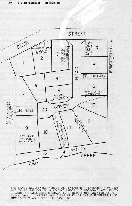 Road Titles in your name?: It is not unusual for a person to hold title to a parcel of land that they have no rights over because that parcel has been dedicated on the plan of title by a notation referring to the lot as, for example, - - Road - Footway - Reserve - Set Apart for Drainage Purposes For simplicity sake lets call these parcels of land Service Lots. Comes about when a Local Council fails to require a subdividor to transfer Service Lots into the name of Council; they stay in the name of the subdividor as their 'Notation' on the plan has a Legal meaning. Generally speaking the use of such land inside these service lots is governed by the exact wording on the plan, the notation. Where the land has been taken over (managed) by a local Council for a public purpose, the land owner may have no right to use the land at all, merely being the registered proprietor of the title. If a plan carries the notations (wording) Road Reserve, Drainage Reserve or Reserve then the lot in question becomes the responsibility of the Crown, even if the name on the title is the original subdivider. SIMPLY: This means that in the past when a subdivision was undertaken those lots that were to become road or Public Open Space or the like sometimes were not transferred to the relevant Council or body. The title stayed in the name of the subdivider. Normally you have no right of use to this land except as a member of the public. It is like holding the land in trust for the public. HOW WE ASSIST : We can determine the status of your entitlement and advise you of your rights. |
Road WideningRoad Widening: refers to the dedication of land on a Sealed Plan for the purpose of widening a road. Quite often is permit condition with the Council being 'allowed' to take up to 9.00 metres from the centreline of the existing construction free of charge. Any requirement in excess of this should be compensated for, although this rarely occurs as most Councils will accept a bit of 'give and take' with this requirement. Should not be confused with "Required for Widening", which is not a separate lot on a Sealed Plan but just a dedication. Note that in a lot of cases simply refers to land taken for future widening of the physical road construction; it is rare that the subdividor is required to actually widen the road formation also, unless needed to satisfy an engineering deficiency exacerbated by the approval of the development. However, fencing of the new setback line as a permit condition can be onerous and is sometimes the subject of a Part V Agreement, where fencing of the new line is required within a certain number of years (for example). |
Roads & HighwaysRoads & Highways: An explanation of the terms Road and Highway: The term “road” means a corridor of land shown on a map or plan that may or may not be constructed or open to the public for access purposes. Unmade road lines are either private land or reserved crown land. The term “highway” means a corridor of land maintained by the state or local highway authority and open for continuous use by the public. There are two categories of highways in Tasmania, being “state highways” that are maintained by the state highway authority and “local highways” that are maintained by local municipal councils. Can a person construct a highway? A private land owner may open a local highway with the consent of his or her local municipal council- If a corridor of land has previously been set aside for a road, a land owner will need to utilize the provisions of Part II, Local Government (Highways) Act 1982 If a corridor of land is being created as part of an approved plan of subdivision, a land owner will need to utilize the provisions of Part 2, Local Government (Building and Miscellaneous Provisions) Act 1993. With regard to opening a highway, in general terms a land owner will need to – Submit design plans and specifications to council for approval Construct the road at his or her cost Maintain the road for a statutory period Obtain a certificate of completion from Council. Upon completion, the road line then becomes a highway maintainable by council as part of the public municipal road network. There does not appear to be any legislative mechanism for a private land owner constructing a highway to gain contributions from other adjoining land owners who may be provided with additional access or benefit from the new highway. Constructing an unmade road line for access purposes It may be possible for a person to gain access over an unmade road line with the consent of the corridor land owner. The consent would normally involve the construction of a private access track or roadway as required. In the case of a crown reserved road line, a licence or right of way must be applied for and granted by the department administering the Crown Lands Act 1976 (presently the Crown Land Services Division, DPIWE). In the case of a privately owned road line, a licence or right of way must be sought from and granted by the corridor land owner. The access rights granted in these types of agreements would not normally provide legal frontage for subdivision purposes. SIMPLY: In general terms we see roads being constructed by local developers at there cost, then being transferred to the local Council after a short maintenance period, to then become the Council’s responsibility. Reserved Roads are Crown land and a licence must be obtained before construction or use can take place. HOW WE ASSIST: We have the knowledge and expertise to advise on the status of ‘roads’ and what is required to obtain the right to use such corridors. |